Strūve Geodetic Arc (Strūves ģeodēziskais loks)
Overview
The Strūve Geodetic Arc is a fascinating UNESCO World Heritage site that spans several countries in Northern Europe, with a significant portion located in the picturesque Cesvaine Municipality of Latvia. This remarkable geodetic survey, conducted in the 19th century, was a groundbreaking scientific achievement that expanded our understanding of the Earth's shape and size. For travelers venturing into the serene landscapes of Latvia, the Strūve Geodetic Arc offers not just historical significance but also a unique glimpse into the intersection of science and culture.
The Strūve Geodetic Arc extends over 2,820 kilometers (approximately 1,750 miles) from Norway to the Black Sea, marking the first accurate measurement of a meridian. The arc was established by the German-born land surveyor Friedrich Georg Wilhelm Struve, who meticulously laid out a series of triangulation points across these vast distances. In Cesvaine, visitors can marvel at the local observatory's historical significance and its role in this grand project. The observatory is situated in a charming rural setting, surrounded by lush forests and tranquil lakes, making it an ideal spot for nature lovers and history buffs alike.
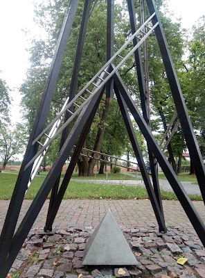
One of the most notable features of the Strūve Geodetic Arc in Cesvaine is the triangulation point that stands as a testament to Struve's pioneering work. This marker, along with others scattered across Latvia and neighboring countries, is a physical reminder of the precision and determination that went into mapping the Earth. Each marker is typically a stone or metal pillar, often with inscriptions that describe its purpose and significance. For travelers, visiting these points can be a delightful adventure, providing opportunities for stunning photographs and moments of reflection on the accomplishments of early scientists.
In addition to its scientific importance, the surrounding area of Cesvaine is rich in cultural and natural beauty. The town is home to the stunning Cesvaine Castle, a neo-Gothic masterpiece that dates back to the late 19th century. The castle, with its elegant turrets and picturesque grounds, makes for a perfect backdrop to your visit to the Strūve Geodetic Arc. Visitors can explore the castle's museum, which showcases local history and art, offering a deeper understanding of the region's heritage.
For those looking to immerse themselves in the local culture, Cesvaine Municipality is known for its warm hospitality and traditional Latvian cuisine. After a day of exploring the geodetic arc and the castle, travelers can indulge in local delicacies at nearby eateries, where you might try dishes like grey peas with speck or potato pancakes. This combination of history, science, and culinary delight makes a visit to the Strūve Geodetic Arc an enriching experience that goes beyond mere sightseeing.
As you plan your journey to Latvia, consider including the Strūve Geodetic Arc in your itinerary. This unique site not only offers a glimpse into the history of geodesy but also allows travelers to connect with the stunning landscapes and rich cultural tapestry of Latvia. Whether you are a history enthusiast, a nature lover, or simply seeking a unique travel experience, the Strūve Geodetic Arc in Cesvaine Municipality promises to leave a lasting impression.


